
6.23.2011
BID Summary
Facts on the Business Improvement Districts influencing/influenced by Columbus Circle, Times Square, and Atlantic Yards.

6.22.2011
New York City is one of the most dense urban areas in the Unites States having set the standard for mixed use, multi-family/multi-unit development, and the accompanying traffic and pedestrians. Each of the areas in my four-week study has changed over time to address traffic and pedestrians needs, incorporating residential concerns and commercial viability with structural resources. Some areas have balanced the public vs. private better than others, resulting in appealing and improved spaces with a strong sense of place. A crucial element that reflects this balance is the inclusion of public/open space in development plans that encourages a range of diverse uses.
Columbus Circle, Atlantic Yards, Times Square, and the High Line all include public/open spaces, either privately-owned such as commercial plazas, city-owned such as parks and intersections, or a combination of private/public such as DOT/BID-encouraged pop-up cafes, intersection improvements, and traffic-calming.
Sources:
6.21.2011
High Line BID Alternatives: Community Representation Beyond the BID
While not directly served by a municipally-approved Business Improvement District (BID), the communities along the High Line are not without representation. Property and business owners in Chelsea, Greenwich Village, and the Meatpacking District have organized various citizens groups, many aimed to preserve the historic buildings and advocate on behalf of local merchants. While many support the High Line development and welcome the subsequent commercial revitalization, these organizations also work to retain and preserve affordability and diversity of the existing business owners, a balance that is difficult to maintain as development increases.
 |
| Source: http://gis.nyc.gov/doitt/nycitymap/ with author additions |
High Line - Insufficient support for BID
While many transitioning area residents and businesses have organized to manage development, the High Line developers were unable to generate adequate support for a business improvement district (BID). In 2009, The High Line Improvement District Steering Committee sought community support for the BID with a plan for the BID to cover "park maintenance services on the High Line itself and possibly the access points to the High Line, not the more usual street level, district-wide security and sanitation services that most BIDs focus on." (High Line FAQs)
6.20.2011
High Line Background: West Chelsea/Gallery District
Building use in West Chelsea has transitioned from manufacturing to warehousing to industrial. During the middle of the twentieth century, highways began to replace rail as the preferred method of freight transportation. By the 1960s, large sections of the High Line were already being dismantled with traffic along the railway halted altogether in 1980.
Beginning in the 1960s, the number of large industrial firms headquartered in Manhattan significantly declined. This decline continued into the 1970s as disinvestment decimated the city’s previously thriving manufacturing economy. The effects of the decline stretched to related sectors as well, taking a toll on trucking, warehousing, and wholesaling. By the 1990s, New York could no longer claim to be an “industrial city.” This economic shift led to new uses for the large spaces of the old industrial buildings, one of the more innovative adaptations being nightclubs in West Chelsea.
The “gritty industrial neighborhood,” as it was described in the New York Times in 1997, began to attract art galleries and related businesses, many which were being priced out of SoHo. Among the attractions for artists of the old industrial buildings were the ground stories featuring wide expanses of column free space, 13-foot ceiling heights, and eight-foot-tall operating windows available in many of the buildings.
Today, West Chelsea remains a thriving district for galleries and art-related businesses, with more than 50 percent of the district’s buildings dedicated to these uses.
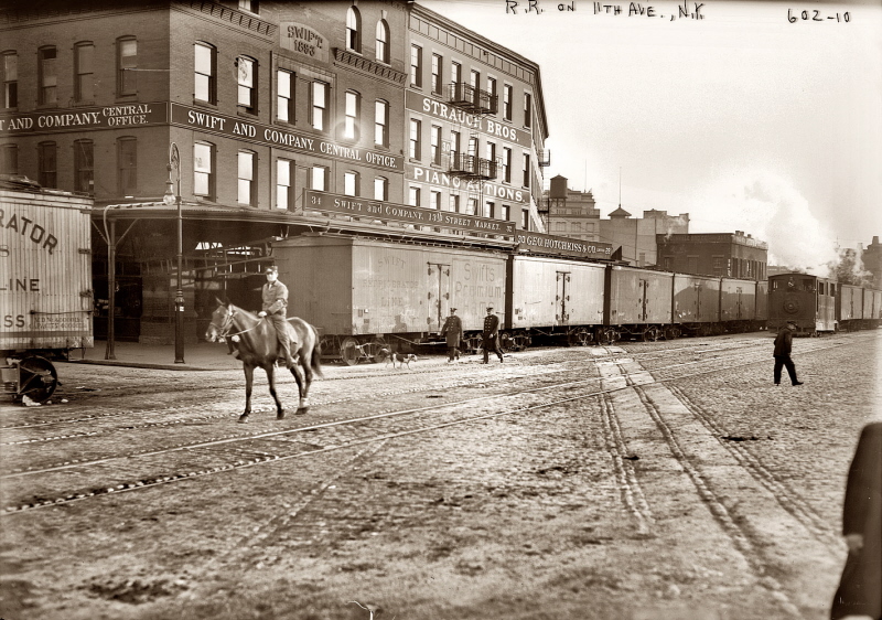 |
| New York Central Railroad - Meat Packing District - Eleventh* Avenue & West 12th Street - ca. 1911 Man on horse is a NYCRR Watchman / RR Policeman a/k/a "West Side Cowboy" escorting the locomotive as required by NY City law. Source: trainweb.com |
 |
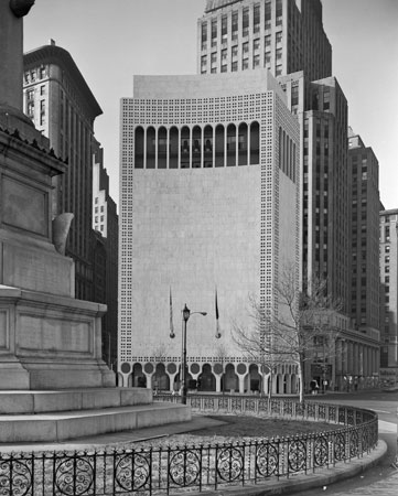
| Source: Gaytravelabout.com |
 |
| The Meatpacking District now includes retail, galleries, restaurants, and hotels. Source: Meatpacking District Improvement Association map 5/2/09 |
Source:
Christopher D. Brazee & Jennifer L. Most, New York City Landmarks Preservation Commission "West Chelsea Historic District Designation Report" July 15, 2008
6.19.2011
Above & Below
 |
| Brian Cronin |
Has the High Line caused gentrification? Who walks above the residents and business owners of the neighborhoods below? Who are the neighbors and business owners impacted most?
While the High Line has been praised and awarded by urbanists, green enthusiasts, visitors and architects, some criticism has come from its closest neighbors. Residents and business owners are coping with the influx of tourist traffic, increasing property values, and new upscale development in West Chelsea, the Meat Packing and Gallery districts.
As a public park, the High Line is available to everyone; however, its success has resulted in higher than expected maintenance costs and increased development interest. For now, Friends of the High Line, the non-profit that manages the park, must raise operating funds privately having abandoned efforts to secure sufficient local support for a business improvement district. As 2-story walk-ups, auto repair shops, and the last few butchers shops are replaced with luxury hotels, innovative architecture, and fashion retail, the contrast between those above and below the High Line will continue to transition.
 |
Neighborhood Context Map Source: thehighline.org |
As a public park, the High Line is available to everyone; however, its success has resulted in higher than expected maintenance costs and increased development interest. For now, Friends of the High Line, the non-profit that manages the park, must raise operating funds privately having abandoned efforts to secure sufficient local support for a business improvement district. As 2-story walk-ups, auto repair shops, and the last few butchers shops are replaced with luxury hotels, innovative architecture, and fashion retail, the contrast between those above and below the High Line will continue to transition.
6.18.2011
High Line Zoning Changes
On June 23, 2005, the City Council approved applications for the West Chelsea/High Line proposal. The adopted actions include Zoning amendments to allow for creation of a new Special West Chelsea District and rezoning portions of the West Chelsea area from M1-5 light manufacturing zoning to allow mixed commercial and residential development. The Council also approved acquisition and site selection of the High Line by the city to facilitate its reuse as a public open space via TDRs. Transferable development rights are means of transferring property rights such as building heights, floor area ratios, and other physical attributes between owners to allow for development/construction flexibility.
| The West Chelsea rezoning proposal contains provisions intended to enhance the proposed High Line open space and to ensure that adjacent developments engage with and relate to the High Line. To encourage preservation of light and air around the High Line, the proposal would allow development rights to be transferred from High Line properties to designated receiving sites within the Special West Chelsea District. New development along Tenth Avenue, adjacent to the High Line, would also be subject to a series of building bulk and use controls to encourage connections to the High Line and the preservation of light, air and views. Source: West Chelsea Zoning Proposal |
6.17.2011
High Line Transitions
 |
| Source: New York Times Aug 2010 |
“The High Line has been a very positive influence to push activities to Washington [St.], which was sort of a back street, but now it’s become very prime,” Mr. Pariser said. (New York Times)
 |
| A rendering of the design for the new Downtown Whitney Museum of American Art on Gansevoort St., viewed from the south. The High Line park is at right. Source: The Villager |
 |
| Source: Urban Sherp June 2009 |
Sources:
The Villager "Whitney Museum is still on track for 2012 opening"
New York Magazine "The High Line: It Brings Good Things to Life"
Urban Sherp "The High Line Greenspace Opens in NYC" June 17, 2009
High Line: Cost, Revenue & Development
Costs:
The first section of the High Line opened to the public in June 2009, at a total cost of $172 million dollars. More than 300,000 visited within the first six weeks. Though the New York City Department of Parks and Recreation provides security for the High Line and maintains its structures and accessibility, Friends of the High Line (FHL) manage day-to-day operations, which are estimated to cost between $3.5 and $4.5 million annually. A proposal to create a Business Improvement District in the area has been withdrawn.
Revenue:
The High Line is credited with bringing new development to the neighborhood. By the end of 2008, there were already 1.5 million square feet of living spaces, offices, and hotels under construction, with an additional 2.5 million square feet in the planning stages. New York City officials expect High Line Park to bring the City $900 million in revenue over the next 30 years and spur $4 billion in private investment.
Speculation & Development:
Several world renowned architects have designed buildings around the High Line, including Frank Gehry, Jean Nouvel, Robert A. M. Stern, Shigeru Ban, Renzo Piano, and Annabelle Selldorf. Many condo units have been pre-sold and developers are reporting success in refinancing construction loans. Interest in real estate and attendance at restaurants near the High Line have both significantly increased since the park's opening.
Broker Matt Bergey with CB Richard Ellis said he’s seen commercial rents rise $2 to $3 per square foot over the past year to the $55 to $60 range. Earlier this year, the Starrett-Lehigh — where Martha Stewart and Tommy Hilfiger are based — changed hands for $900 million. (Marritz)
Sources:
PlanNYC.org "High Line Redevelopment" June 14, 2010
Marritz, Ilya WNYC News "As the High Line Grows, Business Falls in Love with a Public Park" June 07, 2011
Glenwood, readnewyork.com "The High Line New York Section 2 Opens" June 9, 2011
6.16.2011
The High Line Preservation & Public Space
The High Line is a city greenway originally constructed in the early 1930s as a safer alternative part of New York's West Side railway. Extending from the Meatpacking District on the Lower West Side to West 34th Street, level with the Empire State Building, the High Line covers 22 blocks. Since its April 2006 groundbreaking, the innovative re-use project has been showered with praise, spurring visitors and nearby retail and residential development. The design by Field Operations and Diller Scofidio + Renfro consists of a long meandering walkway lined with grass, plants, and trees, with seating and multiple entry/exit points.
"New Yorkers always dream of finding open space—it's a fantasy when you live in a studio apartment," [Joshua David, a freelance writer] David said. "We just wanted to fight Giuliani to keep it from being demolished," Hammond said. "But preservation was only the first step, and we began to realize that we could create a new public place."
 |
| High Line Rail Raising The High Line, Manhattan | April 10, 2006 © Copyright New York City Department of Parks & Recreation |
6.15.2011
Times Square Alliance: Happenings since the BID
The Times Square Alliance, founded in 1992 to make Times Square 'clean, safe, and welcoming." The non-profit:
Development in the Times Square Area (Click for more detail.)
Source: Times Square Alliance
- promotes local businesses; encourages economic development and public improvements;
- co-coordinates numerous major events in Times Square (including the annual New Year's Eve and Broadway on Broadway celebrations);
- manages the Times Square Information Center;
- and advocates on behalf of its constituents with respect to a host of public policy, planning and quality-of-life issues.
- 6,000 Residential Units Built Since 1990 and 6,500 In Development
- 4,863 Units Recently Developed Residential Buildings
- 7,671 Units Existing Large Residential Buildings
 |
| [Author] Selected Times Square Happenings Since BID established |
6.14.2011
Times Square BIDs
As a thriving retail/tourism corrido, Times Square is surrounded by business improvement districts working collectively to keep the area economically and culturally vibrant.
 |
| Source: http://gis.nyc.gov/ |
6.13.2011
Times Square Development
New development slowed as Times Square regained its footing with public safety efforts and revival of entertainment business. More recently, development has increased again including the Times Building construction and residential condominiums along 8th Ave.


Who Lives in Times Square?
According to the Times Square District Management Association, Inc., the Times Square area is not only home to theaters and retailers, but residents, too, many of whom live in the historic mixed-use buildings.


- 33,360 households
- 71% under 50 years old
- Median income of $75, 000 for residents between 25 and 34 years old
- 70% employed in creative occupations (arts, media, publishing, etc.)
- 58% college educated


Times Square
The intersections of Broadway, 42 St., and 7th Ave were formerly known as "Longacre Square" until 1904 when the New York Times raised its headquarters building and catalyzed development. Theatres, neon lights and the subway transformed Times Square into the American icon it is best known as. After decline in the 60s and 70s, political pressures and a crackdown on crime led to a resurgence in the area restoring its heritage as a premier entertainment destination.
 |
Broadway and Times Building (One Times Square), New York City app. 1903-1910 Source : Library of Congress Detroit Publishing Company Collection |
 |
| New York Times Square 1943 Source: Library of Congress Prints and Photographs Division |
 |
| Times Square on a rainy day 1943 Source: Library of Congress Prints and Photographs Division Washington, D.C. 20540 |
 |
Times Square Panorama 2004Source: Wikipedia |
6.12.2011
Fulton Street BID
"Goals are to retain current businesses and improve the atmosphere to make this area of Fulton Street a clean, safe and retail diverse environment that will become a local shopping and civic destination, rather than a thoroughfare."
Top five goals for July 2009 (for FAB, October 2009 start) through June 2010:
- Sanitation (street cleaning & graffiti removal)
- Marketing and Promotion (social media, increased merchants association participation, holiday & retail events)
- Beautification (banners, lighting, street-scaping)
- Public Safety (staffing)
- Advocacy for Members (media & civic engagement)
 |
| Source: http://faballiance.org/programs-initiatives |
 |
| Source: http://www.facebook.com/FABFulton |
Sources:
Fulton Area Business Alliance “Annual Report Submission to the New York City Department of Small Business Services (SBS)” November 5, 2010
Fort Greene / Clinton Hill Rezoning
On July 25, 2007 the City Council adopted Fort Greene / Clinton Hill zoning changes to preserve the area's development scale, limiting the impact of previous zoning without height restrictions that had resulted in inconsistent development. As market demand for housing within Fort Greene and Clinton Hill has increased, a number of out-of-scale, 11- to 13-story tower developments are proposed or have been constructed that are inconsistent with the low-rise, row house neighborhood character. In conjunction with this rezoning, there is a related zoning text amendment to permit the use of the Inclusionary Housing bonus to create incentives for the development and preservation of affordable housing in the R7A districts along Myrtle Avenue, Fulton Street, and Atlantic Avenue.
This rezoning was supported by the Myrtle Ave BID which "to assist the small businesses located along the avenue and improve the quality of life of the surrounding neighborhoods".
 |
| Under the Inclusionary Housing program, a development providing affordable housing are eligible for a floor area bonus, within contextual height limit and bulk regulations tailored to this area. Affordable units can be provided either on-site or off-site. Off-site affordable units must be located within the same community district or within a half-mile of the bonused development if in a different community district. Source: NYC Department of Planning |
 |
| Fort Greene / Clinton Hill Proposed Zoning Source: NYC Department of Planning |
Sources:
Brooklyn BIDs near Atlantic Yards Development
There are a number of business improvement districts (BIDs) in Brooklyn in close proximity to the Atlantic Yards development site.
 |
| Source: http://gis.nyc.gov/ |
6.11.2011
Atlantic Yards: Aging Buildings Spur Change
According to the 2000 Census, much of the housing stock in the immediate vicinity of the Atlantic Yards development was relatively old when plans were announced for the Atlantic Yards development. When housing is in demand, the combination of an aging population and aging housing stock is often a catalyst for new development and gentrification.


6.09.2011
Neighborhood Transitions: Losses & Gains
Contemplating the impact of the Atlantic Yards development project and its impact on the culture of the surrounding communities such as Fort Greene, Clinton Hill, this upcoming project by Nelson George, an advisory board member of DEVELOP DON'T DESTROY BROOKLYN (DDDB), is a volunteer-run and community-funded 501c3 non-profit corporation founded in February 2004 in opposition to the Forest City Ratner plan for Atlantic Yards.
Brooklyn Boheme - First 5 mins TEASER 2011 from Diane Paragas on Vimeo.
Source: http://vimeo.com/24489741
Brooklyn Boheme - First 5 mins TEASER 2011 from Diane Paragas on Vimeo.
"The first five minutes of our feature documentary Brooklyn Boheme gives a first hand account of this vibrant African American artistic community that included the great Spike Lee, Chris Rock, Branford Marsalis, Rosie Perez, Saul Williams, Lorna Simpson just to name a few. Narrated and written by Fort Greene resident Nelson George, this documentary celebrates "Brooklyn's equivalent of the Harlem Renaissance" and follows the rise of a new kind of African American artist, the Brooklyn Boheme."Demographics in Brooklyn are transitioning. Population growth in neighborhoods adjacent to the Atlantic Yards development will increase housing demand as the defining cultural characteristics that make up the "Brooklyn Boheme" continue to shift.
 |
Source: United States Census (2000), Annual Estimates of the Resident Population for Counties of New York (2008,2009), American Community Survey (2009) |
6.08.2011
Atlantic Yards Opposition
The Atlantic Yards development project was publicly announced for the first time in December 2003. Since then, architects and financiers have come and gone and multiple proposals and renderings have been announced. At this point, the final product remains elusive. Local journalists, community activists, and other opponents have criticized many iterations of the planned development.
The Fort Greene and Clinton Hill neighborhoods are predominantly characterized by three-to five-story brownstone row houses. Myrtle Avenue and Fulton Street are the neighborhood's major commercial corridors and are generally characterized by three/four-story apartment buildings with ground-level retail. Much of the opposition is due to the mismatch in scale and character of the proposed Atlantic Yards development.
Bloggers such as author Will James point out the 'developer's blight' and impact on neighborhood vibrancy of the planned development at Atlantic Yards.
"What I hope to show...is the character of the streets both to the north and the south of the railyards. These are overwhelmingly vibrant and beautiful areas...There are some empty and run down buildings here and there around the site, but the vast majority of these are actually owned and kept empty by Bruce Ratner himself."
 |
| Source: developdontdestroy.org DEVELOP DON'T DESTROY BROOKLYN (DDDB), a non-profit corporation founded in February 2004 opposed to Forest City Ratner's 8 million square foot "Atlantic Yards" development.
|
Developer's blight or revitalization?
The use of eminent domain is often controversial when acquiring land and property. Since Kelo vs New London in 2005, US courts have often sided with municipalities that claim increased tax revenue or job growth even at the expense of displacement, gentrification, or community transformation. Empire State Development claims the Atlantic Yards project is a means for "fostering sustainable growth, creating jobs, reviving our economy and expanding opportunities for all New Yorkers." At $4 billion, the project includes 16 residential, office, retail, community facilities, and parking buildings, 8 acres of public space, and is expected to create thousands of construction and permanent jobs. As the much delayed construction continues, the developers continue to push against community opposition with weekly construction updates, glossy renderings, and hearings.
6.07.2011
Atlantic Yards
The Atlantic Yards development project is a controversial mixed-use development project under construction between Prospect Heights and Fort Greene in Brooklyn to include residential and commercial high-rises, as well as a sports arena for the New Jersey Nets. Developer Forest City Ratner has faced tense opposition for various community groups since the plans were announced in 2003 due to questionable use of eminent domain, criticism of design plans, and opposition to changing the character of the surrounding neighborhoods. Currently under construction, the project will undoubtedly change the aesthetics of the Flatbush and Atlantic Avenue corridor and its primarily residential surrounding communities.


6.05.2011


6.04.2011

6.03.2011
Columbus Circle: 1905 to present
Development around the Columbus Circle has often been controversial with a variety of architects, moguls, developers, and politicians making their mark -- Columbus Circle has evolved as a convergence of public use, corporate interests and innovative aesthetics. Identifying more recent impetus for transition and how the existing community influenced the change will be a component of my research.
Sources:
Chicago Tribune
The Castles and Clashes of Columbus Circle
Columbus Monument, Library of Congress Maine Monument Unveiling, Library of Congress 240 Central Park South, Wikimedia New York Coliseum, Library of Congress "Lollipop" Museum, Slate Magazine Trump International Hotel Tower, wikiarquitectura.com Time Warner/Shops at Columbus Circle, World News Network Columbus Circle sketch, Metropolis Magazine Museum of Art & Design, Manhattan Style
Author's own photos
5.27.2011
Columbus Circle: Traffic Circles & Roundabouts
 |
| Columbus Circle at Night Source: New York Time Lapse.com |
Columbus Circle was the very first traffic circle built in the United States in 1905 designed by American architect William Phelps Eno. As a traditional traffic circle, Columbus Circle's design predates smaller modern roundabouts that function without traffic lights. The Columbus Circle intersection has transitioned from difficult and crowded to a local destination. The fountains, artwork, and benches attract tourists, local lunching workers, and nearby residents for resting, picture-taking, and people-watching. The site has even been featured in movies.
5.26.2011
Columbus Circle
An innovative traffic mechanism, a monument to world exploration, and a majestic welcome to Central Park, the Columbus Circle is a historic landmark and nexus of New York's grandest avenues: Broadway, Central Park West, Central Park South, and Eighth Avenue. Anchored by the iconic form of Christopher Columbus since 1892, Columbus Circle has evolved from 1905 to present day to include corporate buildings, green space, luxury hotels, and retail.
 |
View of Columbus Circle I - May 2010Source: http://andrewprokos.com/photos/cityscapes-skylines/view-of-columbus-circle-1/ |
 |
Columbus Circle, Broadway & Central Park West, New York City c 1912Source: Library of Congress Prints and Photographs Division Washington, D.C. 20540 USA Photo copyrighted by Irving Underhill. No. B18329. |
Subscribe to:
Comments (Atom)